Halti hero kuva
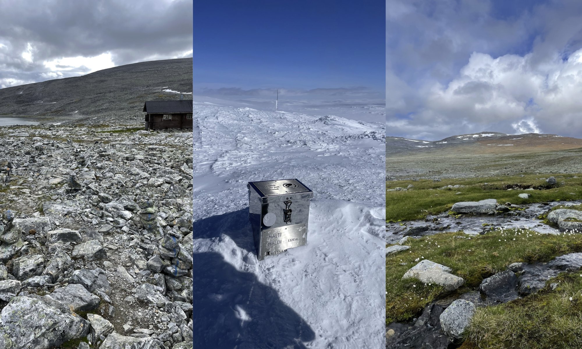
Halti 1324 m
Hiking to Halti tests both your body and your mind. Finland’s highest point is not reached by chance, but step by step, on the fells’ own terms. On this page, we have gathered the different ways to experience Halti: winter ski expeditions and snowmobile safaris, long summer hikes, and day trips from the Norwegian side. Whether your goal is a multi-day wilderness adventure or a single-day summit, Halti offers an experience that will stay with you for a lifetime.
Summiting Halti in Winter
Winter on Halti is a dream for experienced adventurers: vast fell plateaus, an endless horizon, and the northern light make the journey unforgettable. Reaching the summit in winter requires proper equipment, the ability to read the weather, and a multi-day expedition. A faster alternative is a guided snowmobile safari, which operates from early March until the beginning of May.
-
Ski Expedition: Kilpisjärvi – Halti. The classic ski expedition from Kilpisjärvi to Halti is approximately 55 kilometres one way (Kilpisjärvi Nature Centre – Halti). Most travellers divide the journey into 4–5 days, allowing for a steady pace while still leaving time to enjoy the scenery with regular breaks. The route follows Metsähallitus’ maintenance trail (usually marked with poles from February onwards), and overnight stays are made in wilderness or reservable huts at Saarijärvi, Kuonjarjoki, Meekonjärvi, Pihtsusjärvi and Halti – or alternatively in a tent. This journey is a true classic of Lapland ski expeditions: often demanding, but deeply rewarding. The best time for a ski expedition is March–April, when the harshest cold has eased and the sun already brings warmth during the day. The maintenance trail to Halti is not groomed; its condition depends on weather and the number of users. A Halti ski expedition therefore requires flexibility and patience. You must be prepared to postpone your departure entirely, and to adjust plans during the journey according to the weather. Conditions in the fells can change rapidly, and progress is not always safe. Follow weather forecasts carefully before departure and throughout your trip – and ask our reception for advice if needed. All necessary rental equipment for a ski expedition, including backcountry skis and pulks, is available from our rental service.
-
Snowmobile safari: In late winter and spring, Halti can also be experienced on a guided snowmobile safari. The route travels across the fell plateau, offering a chance to witness Halti’s landscapes without committing to a multi-day expedition. These safaris are suitable for adults in basic physical condition who have some prior snowmobiling experience.
This is an efficient and immersive way to reach Finland’s highest point in a true winter setting. In Kilpisjärvi, Halti safaris are organised by operators such as Kilpissafarit, and the duration of the excursion is approximately six hours.
Summer Hike to Halti
In summer, Halti draws hikers with its vast landscapes and Arctic nature. The route from Kilpisjärvi follows the Nordkalott Trail (55 km one way from the Kilpisjärvi Nature Centre), crossing wide fell plateaus, crystal-clear lakes, and rivers. A summer hike typically takes 4–6 days. Nights are spent in Metsähallitus wilderness huts or in a tent, and the route is best suited for experienced hikers. The reward is scenery that seems to stretch from horizon to horizon.
The best hiking season runs from July to mid-September. It is generally not advisable to set out for Halti before Midsummer – the safest choice is to plan your trip for July or later. In the Käsivarsi Wilderness, summer arrives significantly later than in the rest of Finland, and early summer can still bring extensive snow cover. The snow no longer supports weight, and hidden beneath it may be water, rocks, and streams, making progress slow and at times hazardous. Lakes may also remain frozen in June. Conditions can surprise even experienced hikers, so choosing the right timing is an essential part of a safe and successful Halti expedition.
As an alternative to hiking the Nordkalott Trail out and back, you can start from the Norwegian side along the Didnu River. From there, the route to Halti runs via Didnu to Lossujärvi, then through the Urtas Valley to Pihtsusjärvi and onward to the Nordkalott Trail. When starting from the Didnu Valley, car transfer services back to Kilpisjärvi are available from operators such as Tunturikone, if you return to Kilpisjärvi along the Nordkalott Trail after summiting Halti.
At the Kilpisjärvi Shop next to our reception, you will find the maps needed for a Halti hike.
Day Hike to Halti from Guolasjärvi (Norway)
The starting point for a day hike to Halti is located at Guolasjärvi. It is reached from the Norwegian side, driving from the village of Birtavarre through the Kåfjorddalen valley. Toward the end, the road narrows and becomes gravel, passing dramatic gorges, an old mining area, and a narrow wooden bridge. At the end of the road, you will find a small parking area with signs and rest spots. There are no services in the area – every visitor is responsible for carrying out all rubbish and waste.
The best time for the hike is from July to September. In early summer, both the road and the trail may still be covered in snow, and in autumn the first snowfall can end the season quickly. The hike begins west of the parking area, at a gate in the reindeer fence. The path climbs steeply at first and continues mainly through rocky terrain toward the Norwegian summit. The route is not clearly marked throughout, so a map and compass or a dedicated GPS device are strongly recommended. Red markings and cairns can be found along the way, but fog or rain can quickly reduce visibility. From the Norwegian summit, there is still about a two-kilometre walk to Finland’s highest point. This final section is unmarked. On the return, it is best to follow the same route back to Guolasjärvi, as descending into the river valleys may lead onto dangerously steep slopes.
The route is rocky and demanding and is not suitable for small children, dogs, or hikers with poor balance. Trekking poles make the journey easier, and it is important to carry plenty of drinking water – natural water sources are not always easily accessible. Weather can change in an instant, and fog may rise rapidly even on a sunny day.
Distance: approx. 14 km round trip
Time required: 5–6 hours, often longer
After Summiting Halti
When you have reached Finland’s highest point under your own power, you have done something not everyone can. It deserves a memory that lasts. At the Kilpisjärvi Shop next to our reception, you’ll find Halti patches and T-shirts that mark your ascent – proof that you truly made it to the top. Years later, when that shirt or patch turns up in your backpack, it will take you right back to that moment on Finland’s greatest of great fells.